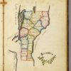
Even without further context, we’d find Frances Henshaw’s 1823 “Book of Penmanship Executed at the Middlebury Female Academy” imaginatively and artistically remarkable. But this 14-year-old girl’s textually-derived maps and cartographically-arranged texts also provide some of our best direct evidence for the teaching practices of famed women’s educational reformer Emma Willard. Willard founded Frances Henshaw’s school at a time when geography was taught almost entirely through prose, and there she developed a new, visual and experimental pedagogy. This led her to assert her own impact on spatial and historical understanding in the early American republic unblushingly: “In history,” wrote Emma Willard, “I have invented the map.” This site houses work in progress by Bethany Nowviskie – an experiment in using Neatline 1.0, a geo-temporal annotation framework created by the Scholars’ Lab for Omeka. The goal here will be to describe and display Frances Henshaw’s work – and to re-position it, in many senses of that word. Mostly, though, it’s an opportunity to test and tinker with Neatline. “Inventing the Map” draws on on research previously published in Poetess and presented at Space/Place/Play and elsewhere. All maps and images are reproduced, with grateful acknowledgment, from the open-access library of David Rumsey.